Online Offline Maps
In general, the Online or Offline map show the path to the station, which is entered in the New QSO window.
The user can choose from two possible maps
-
Online - internet connection is required. The maps uses OpenStreetMap service
-
Offline - no internet connection is required.
The Offline map can be zoomed with the mouse wheel and panned by dragging. The zoom level and map position are remembered between QLog sessions.
When a valid QSO path is displayed, the map automatically adjusts the zoom and position to show the complete great-circle path. If the station and QSO locations span more than 180 degrees of longitude, the complete world map is shown to avoid splitting the path across the map boundary.
Changing the active Station Profile keeps the current zoom level and recenters the map on the new station location.
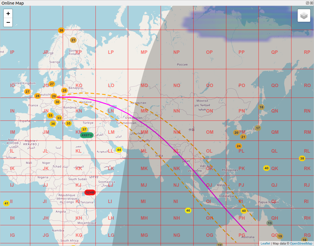
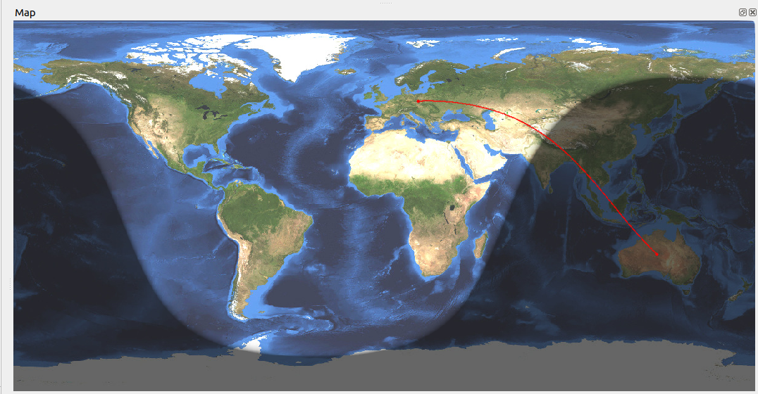
Both maps display signal path between My Location and DX Location.
Online map shows additional layers:
-
Aurora Probability - from the low probability (blue color), through green, yellow and red color with the highest probability.
-
Beam - Shows the antenna beam while the rotator is connected. The orange dashed lines represent the actual rotator azimuth. Their angle is taken from
Azimuth Beam Widthin the active Antenna Profile.Without an active QSO path, the beam covers the full currently visible map. When a purple path to a QSO is displayed, the beam length is limited to the distance of that QSO.
The blue antenna symbol represents the requested azimuth and can be dragged directly to a target location. The resulting great-circle bearing is sent to the rotator. Requests made from the Rotator widget also update the blue symbol, while the orange lines continue to show the actual rotator position.
The selected target remains at its original geographic position while it is visible. If map movement or zoom places it outside the viewport but its direction still crosses the visible map, the symbol temporarily moves to the nearest visible point on the same bearing. It returns to the original location when that location becomes visible again.
Right-clicking the map opens an antenna targeting menu:
- Target Antenna Here - moves the blue target to the selected map location and starts rotating the antenna.
- QSO Short Path - when a purple QSO path is available, points the antenna toward the QSO using the short-path bearing.
- QSO Long Path - points the antenna toward the same QSO using the opposite initial bearing. The blue symbol is displayed in the outgoing long-path direction.
- Stop Antenna - stops an ongoing rotation at the currently reported antenna azimuth.
The antenna actions are enabled only when an antenna path is available from a connected rotator and a valid station locator. The QSO actions are shown only while a purple QSO path is displayed.
-
Chat - Show all Callsigns in User list from ON4KST Chat Window. The maps shows currently selected Char Room User List. Double-click selects the Callsign for the chat.
-
Grids
-
Gray-line
-
Heard Me - This option shows where the operator's transmitted signal has been heard. Reception reports from PSK Reporter and RBN (Reverse Beacon Network) are currently supported. The option is disabled by default.
When the layer is enabled, QLog monitors reception reports in which the
Station Callsignfrom the active Station Profile appears as the transmitting callsign. This value is referred to asMy Callsignin QLog. If the Station Callsign is empty, QLog does not connect to either Heard Me service.Network connections are controlled by the Heard Me layer:
- QLog connects to PSK Reporter while the layer is enabled and a Station Callsign is available.
- QLog additionally connects to RBN when the current mode is
CWorRTTY. RBN remains disconnected in other modes to avoid receiving and processing its high-volume spot stream. - Disabling the layer disconnects both services and clears all currently received Heard Me spots.
The displayed source depends on the current operating mode:
-
CW: CW spots from RBN -
RTTY: RTTY spots from RBN - Other modes: spots from PSK Reporter
Only spots matching the currently tuned band are displayed. A report must also contain a valid frequency and location before it can be placed on the map.
Each circle represents a receiving station or RBN skimmer that reported hearing the operator's Station Callsign. The circles have no permanent callsign labels, distinguishing them from the markers displayed by the WSJTX - CQ layer. Clicking a circle displays the reporting station's callsign and reported value.
QLog keeps one circle for each reporting station, band, and reporting source or mode. A new report from the same station updates the existing circle and restarts its expiration timers.
If no new report is received from the same station, the circle gradually expires:
- PSK Reporter: opacity is reduced by 50% after 30 minutes; the spot is removed after 45 minutes.
- RBN: opacity is reduced by 50% after 5 minutes; the spot is removed after 10 minutes.
A circle with an additional ring (halo) indicates that the reported value exceeds the following threshold:
- PSK Reporter:
SNR > -15 dB - RBN:
SNR > 15 dB
-
IBP - International Beacon Project. The map shows two places. Yellow, which is currently active, and green, which will follow. If the place is marked in red, it is temporary off. A beacon is always displayed depending on the currently tuned band. IBP frequencies are 14.100, 18.110, 21.150, 24.930, 28.200. Double-click of the Callsign tunes the appropriate IBP frequency and mode.
-
MUF - shows the Maximum Usable Frequency. It is the highest frequency that is expected to bounce off of the ionosphere on a path 3000km long. The data displays MUF with a maximum age of 45 minutes. If no current information is available, the point is not displayed.
-
WSJTX - CQ - shows all received WSJTX CQ spots which are displayed in the
WSJTXwidget. Spots are colored according to their status in the log. They gradually disappear based on the time they were received, following this algorithm:- The spot is displayed upon reception.
- If a new callsign message is not received within 30 seconds, the spot's transparency changes to 75%.
- After another 15 seconds, the transparency changes to 50% of the original value.
- After a total of 60 seconds of inactivity, the spot is removed from the map.
Users can click on a spot to tune to the callsign.
If a spot circle has an additional ring around it (halo), the reported signal strength exceeds a predefined threshold:
- PSK Reporter:
SNR > -15 dB - RBN:
SNR > 15 dB
Online maps use the national version of maps if available. The variant is selected based on the language setting of the operating system and the current supported variants are: English, German, French.